

Tap Tap to Zoom
Code: ML-ND-SPORTRAK-980616-02
MPN: 980616-02
Product Info for Magellan Portable GPS Receiver SporTrak Pro - 980616-02
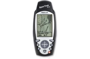
Magellan Portable GPS Receiver SporTrak Pro - 980616-02 is a feature rich, fun, and easy to use GPS receiver designed for everyone. Magellan Portable GPS Receiver SporTrak Pro - 980616-02 has a small, rugged, waterproof, and egronomic design that is perfect for the outdoorsman needing a compact, but powerful navigator. Included in Magellan Portable GPS Receiver SporTrak Pro - 980616-02 is a North American basemap of highways, parks, major roads, waterways, marine navaids, buoys, lighthouses, andmore. 24MB of built-in memory is also included for downloading detailed maps from one of the MapSend line of CD-ROM's. Combine this with a large display and WAAS accurate GPS receiver, and Magellan Portable GPS Receiver SporTrak Pro - 980616-02 is one of the most capable small handheld GPS' on the market today!![]()
Specifications:
| Position Update Rate: | 1 per second | |
| Time to First Fix: | Cold: < 2 minutes/Warm: < 1 minute/Hot: < 15 seconds | |
| Maximum Velocity: | 951 mph (1530.5 km/h) | |
| Display Size: | 2.3" x 1.4" | |
| Display Resolution: | 160 x 104 pixels | |
| Backlit Display: | Yes | |
| Backlit Keypad: | Yes | |
| Construction: | Rubber Armored Impact Resistant Plastic | |
| Antenna: | Quadifiler Helix | |
| Receiver: | 12 Parallel Channel, WAAS enabled | |
| Uploadable Memory: | 24MB built-in | |
| User Data Backup: | Indefinite - stored in Non-volatile Flash Memory | |
| Horizontal Accuracy: | < 7 meters, 95% 2D RMS w/WAAS , 3 meters, 95% 2D RMS | |
| Vertical Accuracy: | 10 meters RMS | |
| Velocity: | 0.1 knots RMS | |
| Basemap: | 8MB Database with interstate highways, state highways, major roads, parks, waterways, airports, cities, marine navaids, buoys, obstructions. | |
| Coverage: | North America | |
| Navigations Screens: | 7 User Configurable (Map, Compass, Large Data, Position, Road, Speedometer, Strip Compass). | |
| Keys: | 9 (Nav, Menu, Goto, Power/Light, Zoom In, Zoom Out, Esc, Arrow) | |
| Waypoints: | 500 | |
| Routes: | 20 | |
| Track Points: | 2000 | |
| Topography Support: | Full 3D Topo Support | |
| Alarms: | Proximity, Arrival, Anchor | |
| Vertical Profiles: | Tracks, Routes, Roads | |
| Grids: | Lat/Lon, UTM, OSGB, MGRS, Finnnish, German, Swedish, French. | |
| Datums: | 76 Datums plus 1 user-defined | |
| Data In/Out: | RTCM 104 (in)/NMEA 0183 V1.5 & 2.1 (out) DGPS Ready | |
| Languages: | English, French, German, Swedish, Finnish, Spanish, Italian, Portuguese, Dutch. | |
| Special Features: | Save Track to Route/Satellite Status Display/Built-in Help/Northfinder with Sun-Moon Positions/Sunrise-Sunset Calculator/Best Fish & Game Calculator/Horizontal Profile/Address Search | |
| POWER: | 2 AA batteries, up to 14 hours battery life. | |
| SIZE: | 2.2"w x 5.6"h x 1.3"d | |
| WTEIGHT: | 7 oz. | |
Features:
- Magellan Portable GPS Receiver SporTrak Pro - 980616-02
- Powerful 12 parallel-channel receiver.
- WAAS enabled for up to 3 meter accuracy.
- Quadifiler Helix antenna for superior tracking in harsh environments.
- 8MB North American basemap of roads, waterways, parks, airports and more.
- 24MB of built-in memory for additional detailed map ownloads.
- 9 key keypad on front face for quick and easy access to software features.
- Large display for easy map readability.
- Rugged, waterproof design that floats.
- Full-featured software including 7 navigation screens.
Related Products to Magellan Portable GPS Receiver SporTrak Pro - 980616-02
Magellan Portable GPS Receiver SporTrak Pro - 980616-02 Unavailable & Discontinued Models
List of Unorderable Models
- Magellan Portable GPS Receiver SporTrak Pro - 980616-02 , MPN: 980616-02 , Code: ML-ND-SPORTRAK-980616-02
